Introduction
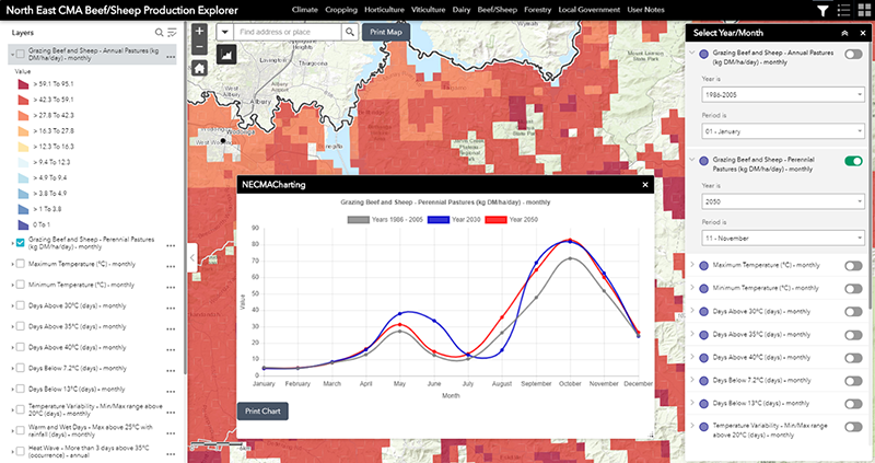
The Beef / Sheep Explorer tool comprises a series of map and graph based views of likely changes in annual pasture growth associated with anticipated changes in the climate. The tool presents the likely changes for annual and perennial pasture systems.
Access to Tool
In using this tool you agree to Accept the North East CMA Terms and Conditions for use. (Click here for NECMA Terms and Conditions)
Accept and Access Tool
Beef and Sheep
Grazing is the largest land use across the North East CMA area, the industry is spread across all local government areas with it being the predominant land use in the local government areas of Towong, East Gippsland and Wangaratta. There are significant infrastructure facilities to support the sector with regional saleyards, abattoirs, feedlots and processing facilities. Grazing has the largest number of farming businesses in North East Victoria, mostly family owned. The sector ranges from large commercial producers to semi-commercial and lifestyle producers. It is estimated that 20% of producers control 80% of the beef cattle numbers.
Of the 20 climate variables selected for presentation in this project, 16 were identified as being of particular interest to beef and sheep graziers.
When you commence using the tool by default, the main map view will always initiate with the top layer in the Displayed Map Theme. For the Beef / Sheep Explorer this will be the modelled pasture growth for Annual Pasture. And the information displayed will be based on the baseline (historic) climate data. You will be able to change the period (to 2030 or 2050), or select another ‘Displayed Map Theme’.
Fact Sheet
A Beef / Sheep Fact Sheet (in pdf format) can be accessed using the tab below.
Beef / Sheep Sector Fact Sheet