Introduction
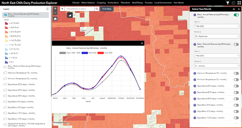
The Dairy Explorer tool comprises a series of map and graph based views of likely changes in annual pasture growth associated with anticipated changes in the climate. The tool presents the likely changes for annual and perennial pasture systems.
Access to Tool
In using this tool you agree to Accept the North East CMA Terms and Conditions for use. (Click here for NECMA Terms and Conditions)
Accept and Access Tool
Dairy
The North East dairy region extends from Benalla and includes the Ovens valley, alpine valleys of the Kiewa and Mitta Mitta rivers, and the upper Murray River valley. Dairy makes a substantial economic contribution: the 164 dairy farms in the north-east produced 256 million litres of milk in 2017-18, worth $113 million at the farm-gate and returning about $90 million to the local economy. While the number of farms has fallen since 2000, milk production nonetheless remained stable during the Millennium drought, and has increased post-drought. This reflects larger herd sizes and improved productivity on the remaining farms. Farm systems in the North East are primarily pasture-based and when conditions are favourable, pasture can be a low cost and low maintenance, high quality feed for dairy livestock. Many farms here have limited or no access to regulated water for irrigation but benefit from high rainfall. Dairy businesses in the North East occupy on average 308 ha per farm, and irrigate approximately 11 per cent of this area. Where farmers from this region have access to regulated water, there is opportunity for increased use of existing water rights to support increased feed-base productivity, particularly in the Ovens and Kiewa river catchments.
Of the 20 climate variables selected for presentation in this project, 16 were identified as being of particular interest to dairy farmers.
When you commence using the tool by default, the main map view will always initiate with the top layer in the Displayed Map Theme. For the Dairy Explorer this will be the modelled pasture growth for Annual Pasture. And the information displayed will be based on the baseline (historic) climate data. You will be able to change the period (to 2030 or 2050), or select another ‘Displayed Map Theme’.
Fact Sheet
A Dairy Fact Sheet (in pdf format) can be accessed using the tab below.
Dairy Sector Fact Sheet