Introduction
The Local Government Explorer Presents key climate variables identified of interest to local government users, in the context of current land use. This tool, together with the other Explorer tools and spatial data, will assist councils support the local agricultural economy and a review of planning processes to build in resilience and adaptation to manage the impacts of climate change.
Access to Tool
In using this tool you agree to Accept the North East CMA Terms and Conditions for use. (Click here for NECMA Terms and Conditions)
Accept and Access Tool
Local Government
Agriculture has a long history in the region, and value adding industries have been established to utilise agricultural production. Local towns also have a relationship with agriculture, with a number of towns and communities providing services for the agriculture and related industries. When agriculture suffers a downturn, there can be significant flow-on impacts through many sectors.
The knowledge and tools developed through the ECAiA will assist councils to support the local agricultural economy (including the ‘local food/paddock to plate’ movement as well as large commodity-based producers). It will also support local government as they continue to modify their own planning processes to build in resilience and adaptation to manage the impacts of climate change.
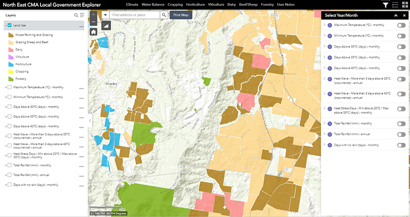
The Local Government Explorer shows current land use, Local Government Association (LGA) boundaries and users can select from the 14 climate variables identified of interest to local government users.
When you commence using the tool by default, the main map view will always initiate with the top layer in the Displayed Map Theme. For the Local Government Explorer this will be current land use, shown together with Mean Monthly Maximum Temperature. The climate information displayed will be for the baseline (historic) data, and for the first month (January). You will be able to change the period (to 2030 or 2050), and month, or select another ‘Displayed Map Theme’.