Introduction
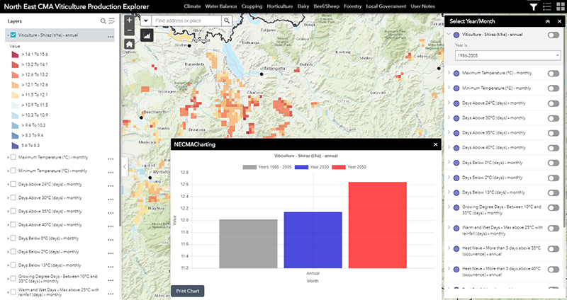
The Viticulture Explorer tool comprises a series of map and graph based views of likely changes in annual crop yields associated with anticipated changes in the climate. The tool presents the likely changes for Shiraz grapes.
Access to Tool
In using this tool you agree to Accept the North East CMA Terms and Conditions for use. (Click here for NECMA Terms and Conditions)
Accept and Access Tool
Viticulture
Viticulture the North East is one of six large wine zones in the Victoria. It comprises five regions with diverse styles and terroirs (sum of the land, water, micro climate, soil type and aspect), leading to a wide range of wines. It is located across predominantly in the local government areas of Wangaratta, Indigo and Alpine. The topography covers the western foothills of the Great Dividing Range, and vineyards sit among the mountains as well as on the plains, resulting in a myriad of meso-climates, varieties reflect the terroir of the region from red wines in the north to cool climate white wines in the south.
Of the 20 climate variables selected for presentation in this project, 17 were identified as being of particular interest to viticulturists.
When you commence using the Viticulture Explorer, by default, the main map view will always initiate with the top layer in the Displayed Map Theme. For the Viticulture Explorer this will be the modelled annual yield for Shiraz grapes. And the information displayed will be based on the baseline (historic) climate data. You will be able to change the period (to 2030 or 2050), or select another ‘Displayed Map Theme’.
Fact Sheet
A Viticulture Fact Sheet (in pdf format) can be accessed using the tab below.
Viticulture Sector Fact Sheet